Typhoon2000 STORM UPDATE #004 **FINAL**
Name: TROPICAL DISTURBANCE WUTIP [DODONG/08W/0707]
Issued: 7:00 AM MANILA TIME (23:00 GMT) FRI 10 AUGUST 2007
Source: JTWC TROPICAL CYCLONE WARNING #010 (FINAL)
Source: JTWC TROPICAL CYCLONE WARNING #010 (FINAL)
_______________________________________________________________________
WUTIP (DODONG) DISSIPATING OVER THE STRAIT OF TAIWAN...
JUST A TROPICAL
DEPRESSION MOVING WEST SLOWLY TOWARDSJUST A TROPICAL
SOUTHERN CHINA. THIS SYSTEM WILL STILL CONTINUE TO PULL
THE SOUTHWEST MONSOON, BRINGING CLOUDY SKIES WITH OCCA-
SIONAL RAINS ACROSS WESTERN LUZON.
**THIS IS THE FINAL UPDATE ON THIS SYSTEM.
+ FORECAST OUTLOOK: Remnants of EX-WUTIP is expected to
continue moving West until it reaches Southern China
tomorrow.
+ EFFECTS: N/A.
+ CURRENT MONSOON INTENSITY: The Southwest (SW) Monsoon
remains under the influence of EX-WUTIP...Cloudy skies with
+ EFFECTS: N/A.
+ CURRENT MONSOON INTENSITY: The Southwest (SW) Monsoon
remains under the influence of EX-WUTIP...Cloudy skies with
occasional rains with SW'ly winds of 20 km/hr or higher can
be expected along Western Luzon - becoming more frequent
over Zambales, Bataan, Pangasinan, La Union, Benguet, and
the Ilocos Provinces. Mudslides and flooding is likely
along river banks, low-lying & flood-prone areas of the
affected areas.
+ TROPICAL CYCLONE WATCH: Two (2) new Tropical Disturbances
+ TROPICAL CYCLONE WATCH: Two (2) new Tropical Disturbances
(LPAs) over the Philippine Sea remains weak. The first
Tropical Disturbance (93W/LPA/1010 MB) was estimated about
575 km NE of Basco, Batanes (24.4N 126.0E)...accelerating
Northerly away from the Philippine Sea.
The second Tropical Disturbance (LPA/1008 MB) on the other
hand was located about 1,670 km ENE of Bicol Region (15.0N
140.0E)...moving NW slowly. These 2 disturbances will be
closely monitored for further development in the days to
come.
Important Note: Please keep in mind that the above forecast
outlook, effects & current monsoon intensity, and tropical
cyclone watch changes every 06 to 12 hours!
____________
TIME/DATE: 5:00 AM MANILA TIME (21:00 GMT) 10 AUGUST
LOCATION OF CENTER: LATITUDE 23.9º N...LONGITUDE 119.1º E
DISTANCE 1: 480 KM (260 NM) NW OF BASCO, BATANES, PH
DISTANCE 2: 120 KM (65 NM) ESE OF XIAMEN, CHINA
DISTANCE 3: 190 KM (102 NM) NW OF KAOSHIUNG, TAIWAN
DISTANCE 4: 280 KM (150 NM) WSW OF TAIPEI, TAIWAN
MAX SUSTAINED WINDS [1-MIN AVG]: 35 KM/HR (20 KTS)DISTANCE 4: 280 KM (150 NM) WSW OF TAIPEI, TAIWAN
PEAK WIND GUSTS: 55 KM/HR (30 KTS)
SAFFIR-SIMPSON SCALE: N/A
MINIMUM CENTRAL PRESSURE (est.): 1007 MILLIBARS (hPa)
RECENT MOVEMENT: WEST @ 09 KM/HR (05 KTS)
GENERAL DIRECTION: SOUTHERN CHINA
STORM'S SIZE (IN DIAMETER): ... KM (... NM)/N/A
MAX WAVE HEIGHT**: 10 FEET (3.0 METERS)
VIEW T2K TRACKING MAP: 2 AM MANILA TIME FRI AUGUST 10
TSR WIND PROBABILITIES: CURRENT TO 36 HRS LEAD
PHILIPPINE STORM SIGNALS*:
#01 - NOW LOWERED.
12 & 24 HR. FORECAST:
2 PM (06 GMT) 10 AUGUST: 24.0N 118.7E / 35-55 KPH / WNW @ 04 KPH
2 AM (18 GMT) 11 AUGUST: 24.2N 118.3E / 30-45 KPH / WNW @ 04 KPH
^IT DOES NOT APPEAR THAT THE LOW LEVEL CIRCULATION CENTER
SURVIVED CROSSING TAIWAN, AS A RESULT, THE CURRENT FORECAST
CALLS FOR THE REMNANTS OF TD WUTIP TO MAKE LANDFALL IN
MAINLAND CHINA NEAR 12 HOURS WITH DISSIPATION SHORTLY
THEREAFTER...(more)
>> WUTIP {pronounced: wu~teep}, meaning: Butterfly, it is
an insect with four broad, colorful wings. You can find
different kinds of butterfly in the countryside of Macau
islands during Spring and Summer. Name contributed
by: Macau, China.
_______________________________________________________________________
by: Macau, China.
____________
_______________________________________________________________________
RECENT TRACKING CHART:
________________________
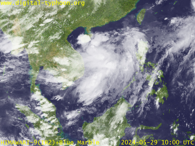
RECENT MTSAT-1R SATELLITE IMAGE:

> Image source: Digital-Typhoon.org (Nat'l. Institute of Informatics) (http://www.digital-typhoon.org )
__________________________________________________________________________________________
NOTES:

> Image source: Digital-Typhoon.
^ - JTWC commentary remarks (for Meteorologists) from their
latest warning.
latest warning.
* - Based on PAGASA's Philippine Storm Warning Signals,
# 4 being the highest. Red letters indicate new areas
being hoisted. For more explanations on these signals,
visit: http://www.typhoon2000.ph/signals.htm
** - Based on the Tropical Cyclone's Wave Height near
its center.
__________________________________________________________________________________________
>> To know the meteorological terminologies and acronyms
used on this update visit the ff:
http://typhoon2000.ph/tcterm.htm
http://www.nhc.noaa.gov/aboutgloss.shtml
http://www.srh.noaa.gov/oun/severewx/glossary.php
http://www.srh.weather.gov/fwd/glossarynation.html
http://www.nhc.noaa.gov/acronyms.shtml
__________________________________________________________________________________________
:: Typhoon2000.com (T2K) Mobile >> Powered by: Synermaxx
Receive the latest storm updates directly to your mobile phones! To know more:
Send T2K HELP to: 2800 (GLOBE & TM) | 216 (SMART & TNT) | 2288 (SUN)
Note: Globe & Smart charges P2.50 per message, while Sun at P2.00.
__________________________________________________________________________________________
For the complete details on TD WUTIP (DODONG)...go visit
our website @:
> http://www.typhoon2000.com
> http://www.maybagyo.com
# 4 being the highest. Red letters indicate new areas
being hoisted. For more explanations on these signals,
visit: http://www.typhoon2
** - Based on the Tropical Cyclone's Wave Height near
its center.
____________
>> To know the meteorological terminologies and acronyms
used on this update visit the ff:
http://typhoon2000.
http://www.nhc.
http://www.srh.
http://www.srh.
http://www.nhc.
____________
:: Typhoon2000.
Receive the latest storm updates directly to your mobile phones! To know more:
Send T2K HELP to: 2800 (GLOBE & TM) | 216 (SMART & TNT) | 2288 (SUN)
Note: Globe & Smart charges P2.50 per message, while Sun at P2.00.
For the complete details on TD WUTIP (DODONG)...go visit
our website @:
> http://www.typhoon2
> http://www.maybagyo
Change settings via the Web (Yahoo! ID required)
Change settings via email: Switch delivery to Daily Digest | Switch format to Traditional
Visit Your Group | Yahoo! Groups Terms of Use | Unsubscribe
SPONSORED LINKS
.
__,_._,___
No comments:
Post a Comment