Typhoon2000 STORM UPDATE #003 **FINAL**
Name: TROPICAL DEPRESSION TORAJI [03W/0703]
Issued: 7:00 AM MANILA TIME (23:00 GMT) FRI 06 JULY 2007
Source: JMA TROPICAL CYCLONE WARNING
Source: JMA TROPICAL CYCLONE WARNING
_______________________________________________________________________
TORAJI (03W) WEAKENED INTO A TROPICAL DEPRESSION AFTER MOVING
INLAND NEAR THE VIETNAM-CHINA BORDER.
*THIS IS THE FINAL UPDATE ON THIS SYSTEM.
+ FORECAST OUTLOOK: TORAJI is expected to dissipate over land *THIS IS THE FINAL UPDATE ON THIS SYSTEM.
(Northern Vietnam) within 03 to 06 hours due to absence of
water vapor and dry air entrainment.
+ EFFECTS: TORAJI's dissipating cloud circulation continues to
cover portions of Northern Vietnam and portions of IndoChina,
bringing widespread rains across the area. Flooding can be
expected along the low-lying areas of Northern Vietnam and
Western Hainan as moderate to heavy rains can be expected
today.
+ TROPICAL CYCLONE WATCH: The Tropical Disturbance (90W/LPA/
1008 MB) over the Philippine Sea has started to cross the
island of Samar. It was located about 215 km ESE of Masbate
or in the vicinity of Borongan, Eastern Samar (11.6N 125.5E)
...with wind speeds of 30 km/hr and was moving WNW at 15
km/hr towards Western Samar-Masbate Area. This disturbance
will be closely monitored for possible development into a
Tropical Depression (TD) once it reaches the Visayan Sea
or the South China Sea. Kindly check out the latest Western
Pacific satellite image regarding this system by clicking
this link.
Meanwhile, another Tropical Disturbance (94W/LPA/1007 MB)
has formed over the Caroline Islands or about 1,030 km SSE
of Guam and 2,250 km ESE of Eastern Mindanao (4.3N 146.7E)
...with wind speeds of 35 km/hr..moving WNW slowly. Majority
of forecast computer models shows this disturbance becoming
an intense typhoon next week (July 11-15). Its early possible
projected path shows Northern Luzon, Taiwan or Okinawa Area.
Watch for more updates on this new threat in the coming days.
Important Note: Please keep in mind that the above forecast
outlook, effects & current monsoon intensity, and tropical
cyclone watch changes every 06 to 12 hours!
____________
TIME/DATE: 2:00 AM MANILA TIME (18:00 GMT) 06 JULY
LOCATION OF CENTER: LATITUDE 22.0º N...LONGITUDE 106.0º E
DISTANCE 1: 115 KM (62 NM) NNE OF HANOI, VIETNAM
DISTANCE 2: 475 KM (257 NM) WNW OF ZHANJIANG, CHINA
DISTANCE 3: 420 KM (225 NM) NW OF DONGFANG, HAINAN IS.
DISTANCE 4: 845 KM (455 NM) WEST OF HONG KONG, CHINA
MAX SUSTAINED WINDS [10-MIN AVG]: 45 KM/HR (25 KTS)PEAK WIND GUSTS: 65 KM/HR (35 KTS)
SAFFIR-SIMPSON SCALE: N/A
MINIMUM CENTRAL PRESSURE (est.): 998 MILLIBARS (hPa)
RECENT MOVEMENT: WEST @ 19 KM/HR (10 KTS)
GENERAL DIRECTION: NORTHERN VIETNAM
STORM'S SIZE (IN DIAMETER): 280 KM (150 NM)/SMALL
MAX WAVE HEIGHT**: 10 FEET (3.0 METERS)
VIEW TRACKING MAP: 8 PM HKT THU JULY 05
TSR WIND PROBABILITIES: CURRENT TO 12 HRS LEAD
PHILIPPINE STORM SIGNALS*: N/A
>> TORAJI {pronounced: to~ra~gee}, meaning: Beautiful flower which
blooms unnoticed, usually found in deep mountains of Korea,
for its usefulness as food and medicine.
Name contributed by: DPR Korea.
____________
_______________________________________________________________________
RECENT TRACKING CHART:
________________________
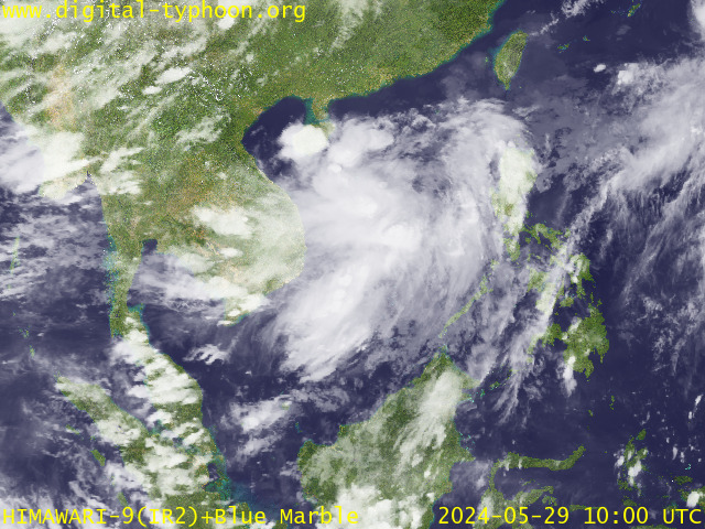
RECENT MTSAT-1R SATELLITE IMAGE:

> Image source: Digital-Typhoon.org (Nat'l. Institute of Informatics) (http://www.digital-typhoon.org )
__________________________________________________________________________________________
NOTES:

> Image source: Digital-Typhoon.
^ - JTWC commentary remarks (for Meteorologists) from their
latest warning.
latest warning.
* - Based on PAGASA's Philippine Storm Warning Signals,
# 4 being the highest. Red letters indicate new areas
being hoisted. For more explanations on these signals,
visit: http://www.typhoon2000.ph/signals.htm
** - Based on the Tropical Cyclone's Wave Height near
its center.
__________________________________________________________________________________________
>> To know the meteorological terminologies and acronyms
used on this update visit the ff:
http://typhoon2000.ph/tcterm.htm
http://www.nhc.noaa.gov/aboutgloss.shtml
http://www.srh.noaa.gov/oun/severewx/glossary.php
http://www.srh.weather.gov/fwd/glossarynation.html
http://www.nhc.noaa.gov/acronyms.shtml
__________________________________________________________________________________________
:: Typhoon2000.com (T2K) Mobile >> Powered by: Synermaxx
Receive the latest storm updates directly to your mobile phones! To know more:
Send T2K HELP to: 2800 (GLOBE & TM) | 216 (SMART & TNT) | 2288 (SUN)
Note: Globe & Smart charges P2.50 per message, while Sun at P2.00.
__________________________________________________________________________________________
For the complete final details on TS TORAJI (03W/0703)...go visit
our website @:
> http://www.typhoon2000.com
> http://www.maybagyo.com
# 4 being the highest. Red letters indicate new areas
being hoisted. For more explanations on these signals,
visit: http://www.typhoon2
** - Based on the Tropical Cyclone's Wave Height near
its center.
____________
>> To know the meteorological terminologies and acronyms
used on this update visit the ff:
http://typhoon2000.
http://www.nhc.
http://www.srh.
http://www.srh.
http://www.nhc.
____________
:: Typhoon2000.
Receive the latest storm updates directly to your mobile phones! To know more:
Send T2K HELP to: 2800 (GLOBE & TM) | 216 (SMART & TNT) | 2288 (SUN)
Note: Globe & Smart charges P2.50 per message, while Sun at P2.00.
For the complete final details on TS TORAJI (03W/0703)..
our website @:
> http://www.typhoon2
> http://www.maybagyo
Change settings via the Web (Yahoo! ID required)
Change settings via email: Switch delivery to Daily Digest | Switch format to Traditional
Visit Your Group | Yahoo! Groups Terms of Use | Unsubscribe
SPONSORED LINKS
.
__,_._,___
No comments:
Post a Comment