Typhoon2000 STORM UPDATE #014
Name: TYPHOON UTOR [SENIANG/25W/0622]
Issued: 7:00 AM MANILA TIME (23:00 GMT) THU 14 DECEMBER 2006
Next Update: 7:00 PM (11:00 GMT) THU 14 DECEMBER 2006
Source: JTWC TROPICAL CYCLONE WARNING #028A
Next Update: 7:00 PM (11:00 GMT) THU 14 DECEMBER 2006
Source: JTWC TROPICAL CYCLONE WARNING #028A
_______________________________________________________________________
TYPHOON UTOR (SENIANG) LOSING STRENGTH RAPIDLY AS POOR
ENVIRONMENT AFFECT ITS CIRCULATION...SHALL DISSIPATE IN
24 TO 36 HOURS .
ENVIRONMENT AFFECT ITS CIRCULATION.
24 TO 36 HOURS
+ FORECAST OUTLOOK: UTOR is expected to continue moving
slowly NW'ly across the South China Sea, turning South-
westward and dissipate in 36 hours. Cool dry air intru-
sion, poor outflow support and strong upper level winds
(Wind Shear) are the reasons why this system shall
dissipate.
+ EFFECTS: UTOR's circulation completely gone...only
low-level clouds affecting the east coast of Hainan.
Important Note: Please keep in mind that the above forecast
outlook, effects & current monsoon intensity, and tropical
cyclone watch changes every 06 to 12 hours!
____________
TIME/DATE: 5:00 AM MANILA TIME (21:00 GMT) 14 DECEMBER
LOCATION OF CENTER: LATITUDE 17.4º N...LONGITUDE 112.1º E
DISTANCE 1: 285 KM (153 NM) ESE OF SANYA, HAINAN IS.
DISTANCE 2: 260 KM (140 NM) SE OF QIONGHAI, HAINAN IS.
DISTANCE 3: 440 KM (237 NM) NE OF DA NANG, VIETNAM
DISTANCE 4: 580 KM (315 NM) SSW OF HONG KONG
MAX SUSTAINED WINDS [1-MIN AVG]: 120 KM/HR (65 KTS)PEAK WIND GUSTS: 150 KM/HR (80 KTS)
SAFFIR-SIMPSON SCALE: CATEGORY ONE (1)
MINIMUM CENTRAL PRESSURE (est.): 976 MILLIBARS (hPa)
RECENT MOVEMENT: NW @ 05 KM/HR (03 KTS)
GENERAL DIRECTION: SOUTH CHINA SEA
STORM'S SIZE (IN DIAMETER): 445 KM (240 NM)/AVERAGE
MAX WAVE HEIGHT**: 30 FEET (9.1 METERS)
VIEW TRACKING MAP: 2 AM PST THU DECEMBER 14
TSR WIND PROBABILITIES: CURRENT TO 72 HRS LEAD
PHILIPPINE STORM SIGNALS*: N/A.
12 & 24 HR. FORECAST:
2 PM (06 GMT) 14 DEC: 17.2N 111.9E / 150-185 KPH / NW @ 05 KPH
2 AM (18 GMT) 15 DEC: 17.2N 111.7E / 55-75 KPH / SW @ 04 KPH
12 & 24 HR. FORECAST:
2 PM (06 GMT) 14 DEC: 17.2N 111.9E / 150-185 KPH / NW @ 05 KPH
2 AM (18 GMT) 15 DEC: 17.2N 111.7E / 55-75 KPH / SW @ 04 KPH
REMARKS: 2 AM (18 GMT) 14 DECEMBER POSITION: 17.4N 112.1E.
^THE FINGER OF THE SUBTROPICAL RIDGE THAT HAD BUILT TO THE NORTH
OF TY UTOR HAS BEEN WEAKENED BY A SERIES OF SHORTWAVE TROUGHS THAT
CONTINUE TO TRAVERSE NORTH OF THE SYSTEM. CONTINUED SLOWING OF THE
SYSTEM IS FORECAST AS THE SYSTEM TRACKS IN A WEAK STEERING ENVIRON-
MENT WITHIN THE WEAKNESS IN THE RIDGE. AS THE SYSTEM WEAKENS, STEER-
ING WILL SWITCH FROM THE MID-LEVEL SOUTHEASTERLIES TO LOW LEVEL
NORTHEASTERLIES, WHICH WILL RESULT IN A WEST-SOUTHWESTWARD TRACK
AFTER 36 HOURS...(more info)
>> UTOR {pronounced: oo-TORE}, meaning: Marshallese word
for "squall line". Name contributed by: U.S.A.
____________
_______________________________________________________________________
RECENT T2K TRACKING CHART:
________________________
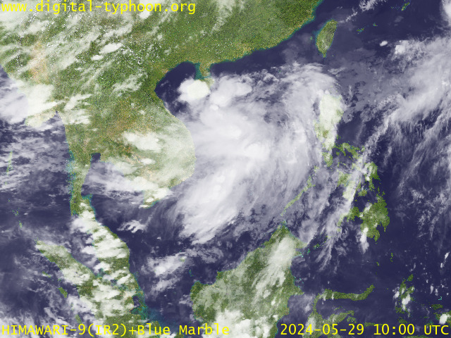
RECENT MTSAT-1R SATELLITE IMAGE:

> Image source: Digital-Typhoon.org (Nat'l. Institute of Informatics) (http://www.digital-typhoon.org )
__________________________________________________________________________________________
NOTES:

> Image source: Digital-Typhoon.
^ - JTWC commentary remarks (for Meteorologists) from their
latest warning.
latest warning.
* - Based on PAGASA's Philippine Storm Warning Signals,
# 4 being the highest. Red letters indicate new areas
being hoisted. For more explanations on these signals,
visit: http://www.typhoon2000.ph/signals.htm
** - Based on the Tropical Cyclone's Wave Height near
its center.
__________________________________________________________________________________________
>> To know the meteorological terminologies and acronyms
used on this update visit the ff:
http://typhoon2000.ph/tcterm.htm
http://www.nhc.noaa.gov/aboutgloss.shtml
http://www.srh.noaa.gov/oun/severewx/glossary.php
http://www.srh.weather.gov/fwd/glossarynation.html
http://www.nhc.noaa.gov/acronyms.shtml
__________________________________________________________________________________________
:: Typhoon2000.com (T2K) Mobile >> Powered by: Synermaxx
Receive the latest storm updates directly to your mobile phones! To know more:
Send T2K HELP to: 2800 (GLOBE & TM) | 216 (SMART & TNT) | 2288 (SUN)
Note: Globe & Smart charges P2.50 per message, while Sun at P2.00.
__________________________________________________________________________________________
For the complete details on TY UTOR (SENIANG)...go visit
our website @:
> http://www.typhoon2000.com
> http://www.maybagyo.com
# 4 being the highest. Red letters indicate new areas
being hoisted. For more explanations on these signals,
visit: http://www.typhoon2
** - Based on the Tropical Cyclone's Wave Height near
its center.
____________
>> To know the meteorological terminologies and acronyms
used on this update visit the ff:
http://typhoon2000.
http://www.nhc.
http://www.srh.
http://www.srh.
http://www.nhc.
____________
:: Typhoon2000.
Receive the latest storm updates directly to your mobile phones! To know more:
Send T2K HELP to: 2800 (GLOBE & TM) | 216 (SMART & TNT) | 2288 (SUN)
Note: Globe & Smart charges P2.50 per message, while Sun at P2.00.
For the complete details on TY UTOR (SENIANG)...
our website @:
> http://www.typhoon2
> http://www.maybagyo
Change settings via the Web (Yahoo! ID required)
Change settings via email: Switch delivery to Daily Digest | Switch format to Traditional
Visit Your Group | Yahoo! Groups Terms of Use | Unsubscribe
SPONSORED LINKS
.
__,_._,___
No comments:
Post a Comment