
Typhoon2000 STORM UPDATE #007
Name: TYPHOON CHEBI [QUEENIE/23W/0620]
Issued: 7:00 AM MANILA TIME (23:00 GMT) SUN 12 NOVEMBER 2006
Next Update: 7:00 PM (11:00 GMT) SUN 12 NOVEMBER 2006
Source: JTWC TROPICAL CYCLONE WARNING #012
_______________________________________________________________________
Next Update: 7:00 PM (11:00 GMT) SUN 12 NOVEMBER 2006
Source: JTWC TROPICAL CYCLONE WARNING #012
____________
TYPHOON CHEBI (QUEENIE) CONTINUES TO WEAKEN AND IS NOW MOVING
AWAY FROM THE PHILIPPINES...STORM SIGNALS DOWNGRADED .
AWAY FROM THE PHILIPPINES.
+ FORECAST OUTLOOK: CHEBI is expected to continue tracking WSW
to West farther away from the Philippines for the next 24 to
48 hours and then turn WNW in the direction of Hainan and Nor-
thern Vietnam. The 3 to 5-day long-range forecast (Nov 15 to
17) shows the system entering the Gulf of Tonkin as a weakened
Tropical Storm by Thursday (Nov 16).
+ EFFECTS: CHEBI's circulation has shrunked considerably and
is no longer affecting any part of the Philippines except for
the coastline provinces of Ilocos Sur, La Union, Pangasinan
& Zambales which are still under the covering of its outer
bands. Cloudy conditions associated with thunderstorms and
passing rains w/ winds of not in excess of 50 km/hr will
still prevail today. Improving weather conditions can be ex-
pected late today or tomorrow. Coastal Storm Surge flooding
of more than 3 to 6 feet above normal tide levels...along
with large and dangerous battering waves can be expected
along the Western Coast of Luzon particularly Pangasinan,
Zambales and La Union.
+ CURRENT MONSOON INTENSITY: Moderate to strong Northeast
Monsoon enhanced by TS CHEBI (QUEENIE) is currently
bringing widespread rains and cool winds across Northeas-
tern Luzon (Cagayan, Isabela, Aurora & Northern Quezon).
Monsoon enhanced by TS CHEBI (QUEENIE) is currently
bringing widespread rains and cool winds across Northeas-
tern Luzon (Cagayan, Isabela, Aurora & Northern Quezon).
outlook, effects & current monsoon intensity, and tropical
cyclone watch changes every 06 to 12 hours!
____________
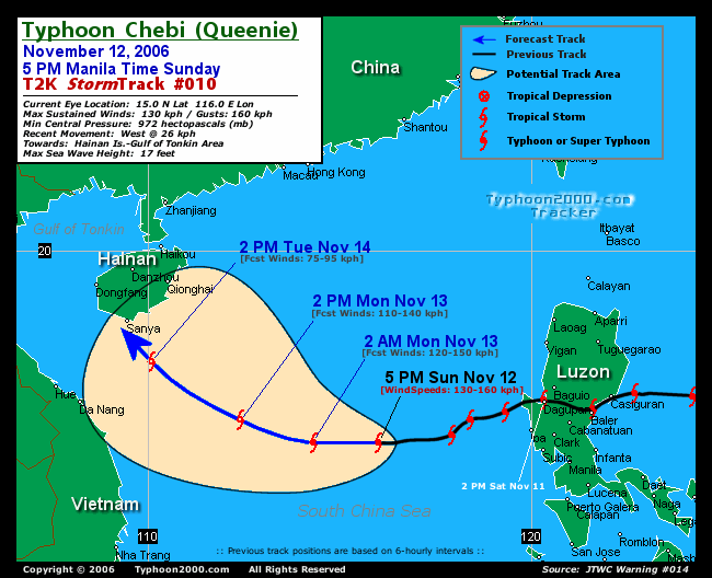
TIME/DATE: 5:00 AM MANILA TIME (21:00 GMT) 12 NOVEMBER
LOCATION OF CENTER: LATITUDE 15.5º N...LONGITUDE 117.9º E
DISTANCE 1: 265 KM (143 NM) OF WSW OF DAGUPAN CITY
DISTANCE 2: 305 KM (165 NM) WSW OF BAGUIO CITY
DISTANCE 3: 270 KM (145 NM) NW OF SUBIC BAY
DISTANCE 4: 360 KM (195 NM) NW OF METRO MANILA
PEAK WIND GUSTS: 185 KM/HR (100 KTS)
SAFFIR-SIMPSON SCALE: CATEGORY 0NE (1)
MINIMUM CENTRAL PRESSURE (est.): 963 MILLIBARS (hPa)
RECENT MOVEMENT: WSW @ 17 KM/HR (09 KTS)
GENERAL DIRECTION: SOUTH CHINA SEA
STORM'S SIZE (IN DIAMETER): 480 KM (260 NM)/AVERAGE
MAX WAVE HEIGHT**: 18 FEET (5.4 METERS)
VIEW TRACKING MAP: 5 AM PST SUN NOVEMBER 12
TSR WIND PROBABILITIES: CURRENT TO 120 HRS LEAD
PHILIPPINE STORM SIGNALS*:
#01 - WESTERN PANGASINAN & ZAMBALES.
12, 24 & 48 HR. FORECAST:
2 PM (06 GMT) 12 NOV: 15.3N 116.3E / 150-185 KPH / W @ 19 KPH
2 AM (18 GMT) 13 NOV: 15.4N 114.3E / 140-165 KPH / WNW @ 15 KPH
2 AM (18 GMT) 14 NOV: 16.4N 111.0E / 120-150 KPH / NW @ 11 KPH
12, 24 & 48 HR. FORECAST:
2 PM (06 GMT) 12 NOV: 15.3N 116.3E / 150-185 KPH / W @ 19 KPH
2 AM (18 GMT) 13 NOV: 15.4N 114.3E / 140-165 KPH / WNW @ 15 KPH
2 AM (18 GMT) 14 NOV: 16.4N 111.0E / 120-150 KPH / NW @ 11 KPH
REMARKS: 2 AM (18 GMT) 12 NOVEMBER POSITION: 15.6N 118.4E.
^TY Chebi will continue to track westward along the southern
periphery of the subtropical ridge (str) until 24 hours. After
that, TY Chebi will begin a gradual turn poleward towards a
weakness in the str near Hainan Island, China. The weakness
will be developed by multiple shortwave troughs advancing
from the northwest. The available dynamic aids are in good
agreement with this scenario through 72 hours...(more info)
>> CHEBI {pronounced: je~bi}, meaning: A swallow. A small
bird with long wings and a forked tail that eats insects,
which visits Korea in Spring. Name contributed by:
Republic of Korea.
____________
PAGASA CURRENT POSITION, MOVEMENT AND INTENSITY (10-min. ave.):
> 4 AM (20 GMT) 12 NOVEMBER: 15.5N 118.7E / W @ 17 KPH / 120 kph
:: For the complete PAGASA bulletin, kindly visit their website
at: http://www.pagasa.dost.gov.ph/wb/tcupdate.shtml
:: For the complete PAGASA bulletin, kindly visit their website
at: http://www.pagasa.
_______________________________________________________________________
RECENT T2K TRACKING CHART:
________________________
RECENT MTSAT-1R SATELLITE IMAGE:

> Image source: Digital-Typhoon.org (Nat'l. Institute of Informatics) (http://www.digital-typhoon.org )
__________________________________________________________________________________________
NOTES:
> Image source: Digital-Typhoon.
^ - JTWC commentary remarks (for Meteorologists) from their
latest warning.
latest warning.
* - Based on PAGASA's Philippine Storm Warning Signals,
# 4 being the highest. Red bold letters indicate new
areas being hoisted. For more explanations on these
signals, visit: http://www.typhoon2000.ph/signals.htm
** - Based on the Tropical Cyclone's Wave Height near
its center.
__________________________________________________________________________________________
>> To know the meteorological terminologies and acronyms
used on this update visit the ff:
http://typhoon2000.ph/tcterm.htm
http://www.nhc.noaa.gov/aboutgloss.shtml
http://www.srh.noaa.gov/oun/severewx/glossary.php
http://www.srh.weather.gov/fwd/glossarynation.html
http://www.nhc.noaa.gov/acronyms.shtml
__________________________________________________________________________________________
:: Typhoon2000.com (T2K) Mobile >> Powered by: Synermaxx
Receive the latest storm updates directly to your mobile phones! To know more:
Send T2K HELP to: 2800 (GLOBE & TM) | 216 (SMART & TNT) | 2288 (SUN)
Note: Globe & Smart charges P2.50 per message, while Sun at P2.00.
__________________________________________________________________________________________
For the complete details on TY CHEBI (QUEENIE)...go visit
our website @:
> http://www.typhoon2000.com
> http://www.maybagyo.com
# 4 being the highest. Red bold letters indicate new
areas being hoisted. For more explanations on these
signals, visit: http://www.typhoon2
** - Based on the Tropical Cyclone's Wave Height near
its center.
____________
>> To know the meteorological terminologies and acronyms
used on this update visit the ff:
http://typhoon2000.
http://www.nhc.
http://www.srh.
http://www.srh.
http://www.nhc.
____________
:: Typhoon2000.
Receive the latest storm updates directly to your mobile phones! To know more:
Send T2K HELP to: 2800 (GLOBE & TM) | 216 (SMART & TNT) | 2288 (SUN)
Note: Globe & Smart charges P2.50 per message, while Sun at P2.00.
For the complete details on TY CHEBI (QUEENIE)...
our website @:
> http://www.typhoon2
> http://www.maybagyo
Change settings via the Web (Yahoo! ID required)
Change settings via email: Switch delivery to Daily Digest | Switch format to Traditional
Visit Your Group | Yahoo! Groups Terms of Use | Unsubscribe
SPONSORED LINKS
.
__,_._,___

No comments:
Post a Comment