
Typhoon2000 STORM UPDATE #004
Name: TYPHOON XANGSANE [MILENYO/18W/0615]
Issued: 7:00 PM MANILA TIME (11:00 GMT) WED 27 SEPTEMBER 2006
Next Update: 7:00 AM (23:00 GMT) THU 28 SEPTEMBER 2006
Source: JTWC TROPICAL CYCLONE WARNING #008
_______________________________________________________________________
Next Update: 7:00 AM (23:00 GMT) THU 28 SEPTEMBER 2006
Source: JTWC TROPICAL CYCLONE WARNING #008
____________
XANGSANE (MILENYO) RAPIDLY STRENGTHENS INTO A CATEGORY
4 TYPHOON WITH WINDS OF 215 KM/HR...NOW OVER EASTERN
SORSOGON.
4 TYPHOON WITH WINDS OF 215 KM/HR...NOW OVER EASTERN
SORSOGON.
+ FORECAST OUTLOOK: XANGSANE is expected to continue to
track WNW for the next 2 to 3 days and weaken slightly
- due to interaction of Luzon's land mass. The Eye and
its core is forecast to make landfall over Legazpi
City and pass over head Mayon Volcano around 8 PM
tonight, continuing moving across Polangui, Albay and
shall be over Iriga City-Baao Area around 12 Midnight
(Thu Sep 28). XANGSANE shall be in the vicinity of
Pili, Camarines Sur or about 10 km. South of Naga City
around 2 or 3 AM tomorrow (Thu) and shall cross the
Ragay Hills passing over Quirino Highway around 6 AM
tomorrow. This typhoon shall move across Southern
Quezon tomorrow afternoon before heading towards
Laguna-Metro Manila Area. The 30 to 48-hour (Sep 28 to
30) Medium-Range Forecast shows XANGSANE passing over
Metro Manila tomorrow evening around 7 PM before exiting
the South China Sea via Subic Bay early Friday morning.
XANGSANE shall maintain Typhoon status over the South
China Sea as it heads for Vietnam area by Sunday or
Monday (Oct 1 or 2). All interests in the Bicol, Quezon
and Southern Tagalog Provinces should closely monitor
the progress of this dangerous Typhoon.
+ EFFECTS: XANGSANE's Eyewall is now affecting Rapu-Rapu
& Bacacay Islands, Sorsogon, and the whole of Albay.
While, its inner bands continues to spread across Bicol
Region, Northern and Western Samar, Ticao & Burias Islands
& Masbate. Outer Bands continues to affect Metro Manila,
Southern Tagalog Provinces & the whole of Visayas including
Boracay Beach Resort and is now spreading across Central
Luzon. Cloudy with moderate to heavy rains and winds not in
excess of 55 km/hr can be expected today along its outer
bands...while increasing wind speeds along its inner bands.
Meanwhile, extreme typhoon conditions can be expected tonight
and tomorrow along Bicol Region and Southern Quezon as XANG-
SANE's core (eye + eyewall) passes by. Coastal Storm Surge
flooding of 13 to 18 feet above normal tide levels...along
with large and dangerous battering waves can be expected
near and to the north or east of where the center of Xang-
sane makes landfall in Bicol Region particularly the
provinces of Albay & Sorsogon tonight.
outlook, effects & current monsoon intensity, and tropical
cyclone watch changes every 06 to 12 hours!
____________
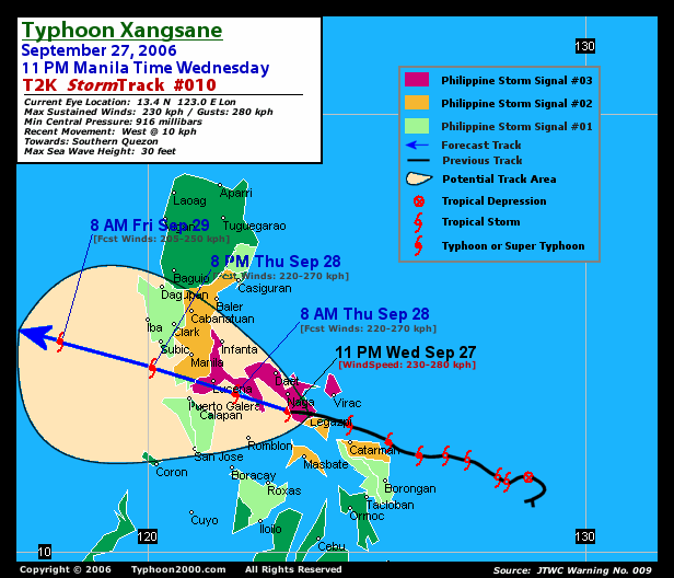
TIME/DATE: 5:00 PM MANILA TIME (21:00 GMT) 27 SEPTEMBER
LOCATION OF EYE: LATITUDE 13.1º N...LONGITUDE 124.2º E
DISTANCE 1: 55 KM (30 NM) EAST OF LEGAZPI CITY, ALBAY
DISTANCE 2: 55 KM (30 NM) SOUTH OF VIRAC, CATANDUANES
DISTANCE 3: 120 KM (65 NM) ESE OF NAGA CITY, CAM SUR
DISTANCE 4: 180 KM (98 NM) SE OF DAET, CAMARINES NORTE
PEAK WIND GUSTS: 260 KM/HR (140 KTS)
SAFFIR-SIMPSON SCALE: CATEGORY FOUR (4)
MINIMUM CENTRAL PRESSURE (est.): 927 MILLIBARS (hPa)
RECENT MOVEMENT: WNW @ 19 KM/HR (10 KTS)
GENERAL DIRECTION: ALBAY-CAMARINES SUR
STORM'S SIZE (IN DIAMETER): 665 KM (360 NM)/AVERAGE/LARGE
MAX WAVE HEIGHT**: 30 FEET (9.1 METERS)
VIEW T2K TRACKING MAP: 5 PM HKT WED SEPTEMBER 27
TSR WIND PROBABILITIES: CURRENT TO 120 HRS LEAD
PHILIPPINE STORM SIGNALS*:
#03 - SORSOGON, CATANDUANES, CAMARINES PROVINCES, SOU-
THERN QUEZON, POLILLO ISLAND, MARINDUQUE, MASBATE,
ALBAY, BURIAS ISLAND, SAMAR PROVINCES, TICAO ISLAND.
#02 - ROMBLON, REST OF QUEZON, BATANGAS, LAGUNA, RIZAL,
ORIENTAL MINDORO, NORTHERN LEYTE & BILIRAN ISLAND.
#01 - OCCIDENTAL MINDORO, CAVITE, BULACAN, BATAAN, PAMPANGA,
NUEVA ECIJA, AURORA, METRO MANILA, SOUTHERN LEYTE,
CAMOTES ISLAND, NORTHERN CEBU, NORTHERN ILOILO,
NORTHERN ANTIQUE, AKLAN, CAPIZ, DINAGAT & SIARGAO
ISLANDS.
12, 24 & 48 HR. FORECAST:
2 AM (18 GMT) 28 SEP: 13.5N 123.2E / 185-230 KPH / WNW @ 15 KPH
2 PM (06 GMT) 28 SEP: 14.2N 121.7E / 165-205 KPH / WNW @ 17 KPH
2 PM (06 GMT) 29 SEP: 14.9N 120.0E / 150-185 KPH / WNW @ 20 KPH
REMARKS: 2 PM (06 GMT) 27 SEPTEMBER POSITION: 12.9N 124.6E.
^STRONG RIDGING ANCHORED OVER SOUTHEASTERN CHINA HAS STEERED
TY XANGSANE WEST-NORTHWESTWARD OVER THE PAST 12 HOURS. TY
XANGSANE WILL CONTINUE TO TRACK WEST-NORTHWESTWARD THROUGH
AS THE STEERING RIDGE MAINTAINS THIS ORIENTATION THROUGH 36
HOURS. THEREAFTER, A MIDLATITUDE TROUGH WILL CAUSE THE RIDGE
TO REORIENT ON A MORE EAST-WEST AXIS, AND AS A RESULT, TY
XANGSANE WILL BEGIN TO TRACK WESTWARD ALONG THE SOUTHERN
PERIPHERY OF THE RIDGE. WHILE THE FORWARD SPEED OF TY XANGSANE
IS NOT EXPECTED TO DECREASE AS IT PASSES OVER THE PHILIPPINE
ISLANDS, IT WILL BEGIN TO ACCELERATE ONCE IT MOVES OVER THE
SOUTH CHINA SEA...(more info)
>> XANGSANE {pronounced: xang~sa}, meaning: Elephant.
Name contributed by: Laos
____________
PAGASA CURRENT POSITION, MOVEMENT AND INTENSITY (10-min. ave.):
> 4 AM (08 GMT) 27 SEPTEMBER: 13.0N 124.3E / WNW @ 13 KPH / 130 kph
:: For the complete PAGASA bulletin, kindly visit their website
at: http://www.pagasa.dost.gov.ph/wb/tcupdate.shtml
_______________________________________________________________________
:: For the complete PAGASA bulletin, kindly visit their website
at: http://www.pagasa.
____________
RECENT T2K TRACKING CHART:
________________________
RECENT MTSAT-1R SATELLITE IMAGE:

> Image source: Digital-Typhoon.org (Nat'l. Institute of Informatics) (http://www.digital-typhoon.org )
__________________________________________________________________________________________
NOTES:
> Image source: Digital-Typhoon.
^ - JTWC commentary remarks (for Meteorologists) from their
latest warning.
latest warning.
* - Based on PAGASA's Philippine Storm Warning Signals,
# 4 being the highest. Red letters indicate new areas
being hoisted. For more explanations on these signals,
visit: http://www.typhoon2000.ph/signals.htm
** - Based on the Tropical Cyclone's Wave Height near
its center.
__________________________________________________________________________________________
>> To know the meteorological terminologies and acronyms
used on this update visit the ff:
http://typhoon2000.ph/tcterm.htm
http://www.nhc.noaa.gov/aboutgloss.shtml
http://www.srh.noaa.gov/oun/severewx/glossary.php
http://www.srh.weather.gov/fwd/glossarynation.html
http://www.nhc.noaa.gov/acronyms.shtml
__________________________________________________________________________________________
:: Typhoon2000.com (T2K) Mobile >> Powered by: Synermaxx
Receive the latest storm updates directly to your mobile phones! To know more:
Send T2K HELP to: 2800 (GLOBE & TM) | 216 (SMART & TNT) | 2288 (SUN)
Note: Globe & Smart charges P2.50 per message, while Sun at P2.00.
__________________________________________________________________________________________
For the complete details on TY XANGSANE (MILENYO)...go visit
our website @:
> http://www.typhoon2000.com
> http://www.maybagyo.com
# 4 being the highest. Red letters indicate new areas
being hoisted. For more explanations on these signals,
visit: http://www.typhoon2
** - Based on the Tropical Cyclone's Wave Height near
its center.
____________
>> To know the meteorological terminologies and acronyms
used on this update visit the ff:
http://typhoon2000.
http://www.nhc.
http://www.srh.
http://www.srh.
http://www.nhc.
____________
:: Typhoon2000.
Receive the latest storm updates directly to your mobile phones! To know more:
Send T2K HELP to: 2800 (GLOBE & TM) | 216 (SMART & TNT) | 2288 (SUN)
Note: Globe & Smart charges P2.50 per message, while Sun at P2.00.
For the complete details on TY XANGSANE (MILENYO)...
our website @:
> http://www.typhoon2
> http://www.maybagyo
Change settings via the Web (Yahoo! ID required)
Change settings via email: Switch delivery to Daily Digest | Switch format to Traditional
Visit Your Group | Yahoo! Groups Terms of Use | Unsubscribe
SPONSORED LINKS
.
__,_._,___

No comments:
Post a Comment