Typhoon2000 STORM UPDATE #08
Name: TROPICAL STORM JELAWAT [DOMENG/03W/0602]
Issued: 7:00 PM MANILA TIME (11:00 GMT) WED 28 JUNE 2006
Next Update: 7:00 AM (23:00 GMT) THU 28 JUNE 2006
Source: JTWC TROPICAL CYCLONE WARNING #009
_______________________________________________________________________
Next Update: 7:00 AM (23:00 GMT) THU 28 JUNE 2006
Source: JTWC TROPICAL CYCLONE WARNING #009
_______________________________________________________________________
TROPICAL STORM JELAWAT (DOMENG) WEAKENS AS IT PASSES OVER
NORTHERN HAINAN ISLAND..
.NOW HEADING TOWARDS SOUTHWESTERNNORTHERN HAINAN ISLAND..
CHINA.
+ FORECAST OUTLOOK: JELAWAT is expected to make landfall over SW
China tonight. This system is forecast to dissipate over China
tomorrow due to land effects and the absence of warm moisture.
+ EFFECTS: JELAWAT's main core (inner rain bands) is now off the
Northeastern Coast of Hainan Island with its outer bands spreading
well across Hainan, Coastal Guangdong and the Gulf of Tonkin. The
storm's core particularly the inner & outer bands are expected to
bring moderate to heavy torrential rains with strong winds that
could produce flying debris, life-threatening flash floods and
mudslides along river banks, low-lying areas and mountain slopes
over the affected areas. Residents residing along the coastal
beachfront areas of Hainan and Guangdong are advised to seek higher
grounds due to possible high waves from the sea. Coastal Storm Surge
flooding from 1 to 3 feet can be expected along the path of this
intensifying storm, thereby advising all sea vessels to remain at
port and avoid passing over it.
+ CURRENT MONSOON INTENSITY: Southwest Monsoon is still being drawn
by this storm towards Palawan and portions of Western Philippines.
The affected area(s) will continue to experience cloudy skies with
light to moderate/heavy rains today. These rains may produce life-
threatening flash floods and mudslides along river banks, low-lying
areas and mountain slopes of the affected areas.
+ TROPICAL CYCLONE WATCH: The Active Low Pressure Area (aka. Tropical
Disturbance) has been drifting NW over the past 6 hours and remains
just to the east of Mindanao...some 235 km ESE of Surigao City (8.8N
127.4E). This system is currently bringing moderate to heavy rains
across the Eastern Coast of Mindanao including Siargao Island and
will be monitored closely for possible development into a Tropical
Cyclone. Please stay tuned.
effects & current monsoon intensity changes every 06 to 12 hours!
_______________________________________________________________________
TIME/DATE: 5:00 PM MANILA TIME (09:00 GMT) 28 JUNE
LOCATION OF CENTER: LATITUDE 20.0º N...LONGITUDE 110.8º E
DISTANCE 1: 55 KM (30 NM) EAST OF HAIKOU, HAINAN ISLAND, CHINA
TIME/DATE: 5:00 PM MANILA TIME (09:00 GMT) 28 JUNE
LOCATION OF CENTER: LATITUDE 20.0º N...LONGITUDE 110.8º E
DISTANCE 1: 55 KM (30 NM) EAST OF HAIKOU, HAINAN ISLAND, CHINA
DISTANCE 2: 95 KM (50 NM) NNE OF QIONGHAI, HAINAN ISLAND, CHINA
DISTANCE 3: 140 KM (75 NM) SSE OF ZHANGJIANG, CHINA
MAX SUSTAINED WINDS [1-MIN AVG]: 65 KM/HR (35 KTS)
PEAK WIND GUSTS: 85 KM/HR (45 KTS)
MINIMUM CENTRAL PRESSURE (est.): 997 MILLIBARS (hPa)
MAX WAVE HEIGHT**: 14 FEET (4.2 METERS)
SAFFIR-SIMPSON SCALE: N/A
RECENT MOVEMENT: NW @ 15 KM/HR (08 KTS)
GENERAL DIRECTION: SOUTHWESTERN CHINA
STORM'S SIZE (IN DIAMETER): 295 KM (160 NM)/SMALL
VIEW T2K TRACKING MAP: 5 PM WED JUNE 28
TSR WIND PROBABILITIES: CURRENT TO 36 HRS LEAD
PHILIPPINE STORM SIGNALS*: N/A
09-21 HR. FORECAST:
> 2 AM (18 GMT) 29 JUNE: 20.7N 109.9E / 45-65 KPH [Landfall]
> 2 PM (06 GMT) 29 JUNE: 21.8N 109.0E / 45-65 KPH [Landfall]
REMARKS: 2 PM (06 GMT) 28 JUNE POSITION: 19.7N 111.1E.
^ TS JELAWAT CONTINUES TO TRACK NORTHWESTWARD AROUND THE
WESTERN PERIPHERY OF A SUBTROPICAL HIGH PRESSURE RIDGE
ANCHORED JUST EAST OF OKINAWA. THE CENTRAL DENSE OVERCAST
(CDO) HAS APPEARED TO MOVE ALMOST DUE WEST OVER THE PAST
12 HOURS. HOWEVER, MULTISPECTRAL IMAGERY AND A 2 AM JUNE
28 AMSR SATELLITE PASS INDICATES THAT THE LOW LEVEL CIR-
CULATION CENTER IS UNDER THE NORTHEAST QUADRANT OF THE
CDO. AN APPROACHING SHORTWAVE LOW PRESSURE TROUGH OVER
EAST-CENTRAL CHINA IS WEAKENING THE RIDGE SLIGHTLY,
WHICH WILL ALLOW JELAWAT TO LIFT TOWARD A MORE NORTHERLY
TRACK MAKING LANDFALL JUST PRIOR TO 24 HOURS.(more info)
>> JELAWAT {pronounced: jer~la~wa~t}, meaning: Also known
as Sultan fish. This fresh-water carp fish is normally
found in big rivers. It is a very tasty fish and very
much sought after by gourmets. Name contributed by:
Malaysia
_______________________________________________________________________
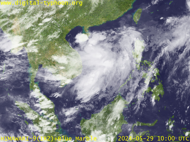
RECENT MTSAT-1R SATELLITE IMAGE:

> Image source: Digital-Typhoon.org (Nat'l. Institute of Informatics) (http://www.digital-typhoon.org)
__________________________________________________________________________________________
LATEST T2K TRACKING CHART:

_______________________________________________________________________________________
NOTES:

> Image source: Digital-Typhoon.org (Nat'l. Institute of Informatics) (http://www.digital-typhoon.org)
__________________________________________________________________________________________
LATEST T2K TRACKING CHART:

_______________________________________________________________________________________
NOTES:
^ - JTWC commentary remarks (for Meteorologists) from their latest warning.
* - Based on PAGASA's Philippine Storm Warning Signals, # 4 being the
highest. Red letters indicate new areas being hoisted. For more
explanations on these signals, visit: http://www.typhoon2000.ph/signals.htm
** - Based on the Tropical Cyclone's Sea Wave Height near its center.
__________________________________________________________________________________________
>> To know the meteorological terminologies and acronyms used on
this update visit the ff:
http://typhoon2000.ph/tcterm.htm
http://www.nhc.noaa.gov/aboutgloss.shtml
http://www.srhnoaa.gov/oun/severewx/glossary.php
http://www.srh.weather.gov/fwd/glossarynation.html
http://www.nhc.noaa.gov/acronyms.shtml
__________________________________________________________________________________________
T2K Mobile: receive the latest storm updates directly to your mobile phones! To know more,
Send T2K HELP to: 2800 (GLOBE & TM) | OFFLINE (SMART & TNT) | 2288 (SUN)
Powered by: Synermaxx
__________________________________________________________________________________________
For the complete details on the TS JELAWAT (DOMENG/03W)...go visit our website @:
> http://www.typhoon2000.com
> http://www.maybagyo.com
:: Kindly view our site's disclaimer at: http://www.typhoon2000.ph/disclaimer.htm
Visit Your Group | Yahoo! Groups Terms of Use | Unsubscribe
SPONSORED LINKS
.
__,_._,___
No comments:
Post a Comment